Today, the islet of Sokastro is a small, steep-sided rocky plateau poking out of the sea with no accessible shoreline. A narrow land bridge once linked Sokastro with Karpathos but tectonic activity in the distant past severed the connection. At present, a narrow and treacherous strait separates the islet from the coast but a recent study publishes evidence that the harbour beaches at Leukos have subsided since antiquity due to seismic events. If so, then the underwater bridge between Sokastro and Leukos must also have subsided. In other words, the harbours at Leukos would have been even more sheltered by the connection with Sokastro from the prevailing north winds than they are today.
No scientifically-based archaeological work had been undertaken on the islet until it was surveyed by Michael Nelson, Amanda Kelly and Todd Brenningmeyer and myself in 2011 under the aegis of the Canadian Institute in Greece with the approval of the Greek Archaeological Service. Most recently see “Late Roman–Early Byzantine Leukos settlement, Karpathos, Greece: Geoarchaeology, archeoseismology, and paleogeography” by Karen L. Kleinspehn and Michael C. Nelson in Geoarchaeology 38.5 September/October 2023: https://doi.org/10.1002/gea.21962
Except for the one building located on the landward side of the islet towards the collapsed land-bridge, the entire settlement was contained within the fortification wall that hugged the outer edges of the lofty plateau. From this it might be inferred that the fortification walls were built at the same time or at least no later than the settlement inside. It was always intended to be fortified.
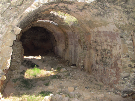
The settlement was once densely packed with many freestanding and abutting buildings. The vast majority of the visible structures are cisterns. Constructed on undulating rocky terrain, the small cisterns probably formed a structurally substantial part of the basements or ground-floors of dwellings.
In addition to the small domestic cisterns, however, there were much larger “community” cisterns. The sheer size of the latter in comparison to the former suggests that the biggest cisterns, which required a sizeable crew of skilled laborers to build, served a large number of people or some purpose not immediately apparent and thus the term “community” was applied. It seems likely that this same sizable crew would also have built the fortification walls.
The fortification walls and the extremely large cisterns suggest some sort of organization or authority which anticipated the possibility of sea raids or sieges. Alternatively, the community cisterns could have provided a ready supply of fresh water for ships transporting goods or pilgrims passing by. It would have to have been carted down from the cisterns because their height above sea level would create too much pressure from the flow to be withstood by any piping system or aqueduct, for which in any case there is no evidence. If the cisterns were intended to replenish naval ships’ water supply, they would have performed the function of the land-based Byzantine aplekta or way-stations, which were set up to supply Byzantine armies on the march through Anatolia. So it is not yet clear if the walls and cisterns were built to protect the settlement, or if the walls and settlement were built to protect the cisterns. And which central authority built them?
To be continued.